
|
Website Links . . .
Home A Guide to Outdoor Literature . (Extensive Outdoor Book Reviews, Award Winners, Lots of Reading Lists, Best Book Lists, and More) Stories & Articles Index Page (Outdoor adventure stories, profiles of old-timers, and reflections of days spent in the outdoors.) Software: (Shareware & Freeware) AnyOrder. AnyCard. Raceaid. AnyBook. Outdoor Resources (Informational Articles, Equipment Lists, etc.) Outdoor Education Papers (Professional Papers for the Outdoor Education Field) Courses Contact |
| . | Winter
Tales and Trails
Skiing, Snowshoeing and Snowboarding in Idaho, the Grand Tetons and Yellowstone National Park Excepts from Winter Tales and Trails: Sample Chapter: Sun Valley & Ketchum | Sample Story | Contents Sample Chapter:
Area Covered: Central Idaho including the surrounding areas of Sun Valley, Galena, Ketchum, Hailey and Bellevue.Sun Valley-Ketchum Region . Copyright Ron Watters - All Rights Reservered What has happened in the Ketchum-Sun Valley Nordic scene over the last few years is nothing short of a miracle. Track skiing—the kind of cross-country skiing that the area is so well suited to—reached a nadir in the early 1990s when the trail systems at Galena Lodge and Busterback Ranch, just over Galena Pass, shut down. A group of inventive and enterprising skiers came to the rescue, and working through the Blaine County Recreation District has, in a few short years, put together a cross-country trail system which ranks among the best in the U.S. Welcome to a place where Nordic skiing is a passion. Welcome to skiing heaven. Nordic skiers have their choice of almost 200 kilometers of groomed trails in the Wood River Valley. Trails are groomed for both classic and skating. Special trails are available to skiers with dogs and others designed for snowshoeing. And, just beyond the groomed trails, in the surrounding mountain ranges, backcountry skiing and snowboarding is rich and abundant. Can it get any better than this? Groomed trails in the Wood River Valley are grouped into three networks. Farthest to the south are the Wood River Trails, which follow the old Union Pacific railroad bed. The railroad tracks have long been taken out and in their place is a paved non-mechanized corridor, which in the summer is a wonderful trail for biking, roller blading and hiking, and in the winter, an equally wonderful trail for cross-country skiing. The trail is 30 kilometers (19 miles) long and connects the communities of Bellevue, Hailey and Ketchum. The next network is the Sun Valley Nordic Center. The Sun Valley trails start just off Sun Valley Road, a short distance beyond the main Sun Valley village. The trails wind around the Sun Valley Golf Course and on the open hillsides on either side of Sun Valley Road. At this writing it has 40 kilometers (25 miles) of groomed trails. Ski passes for the Sun Valley system can be purchased at the Sun Valley Nordic Center’s office where the trails start. The third, and largest, network is called the North Valley Trails which includes trail systems along a 19 mile stretch of Idaho 75 from just north of Ketchum to Galena Lodge. The first set of trails is 3 miles north of Ketchum on Idaho 75 at Lake Creek. Lake Creek is where the Sun Valley Nordic team practices, but the trails are available to everyone. From Lake Creek north on Idaho 75 there’s a 4.5 mile gap, but the trails start again at the Sawtooth National Recreation Area Headquarters, with the North Fork, Billy’s Bridge and Prairie Creek trail systems. At the northern most end of the Wood River Valley is the last of the North Valley Trails, the Galena Lodge System. Galena Lodge, the final jewel in the Wood River crown, has 50 kilometers of groomed trails. The trail system starts from the rustic lodge which serves meals, rents skis and snowshoes, and whose managers can always be relied upon for the best of skiing advice. The lodge also rents out a couple of yurts which, reached from the groomed trail system, are designed especially for those looking for a tamed overnight experience. The Wood River Valley is, of course, the home of the world famous Sun Valley Ski Area. There are few mountains with fall lines as true and grooming as meticulously done as at Bald Mountain. The mountain has two access points: Warm Springs on the north side and River Run on the east side. Also, don’t forget about Dollar Mountain Ski Area. It is a small area, but its gradual slopes are great for families and those learning how to ski. The lift starts at the small village of Elkhorn over the hill from Sun Valley or at Dollar Mountain Cabin, on the southeast edge of Sun Valley. Besides all this, great opportunities exist for backcountry skiing and snowboarding. This was the stomping grounds of Idaho backcountry skiing pioneer Andy Hennig, the Sun Valley Ski School instructor who was one of the most prolific backcountry skiers of the pre and post war era. He explored and skied elegant descent lines throughout the three ranges encircling the area: the Pioneer Mountains to the south and east of Sun Valley, and the Boulder Mountains which parallel the right or east side of Idaho 75 driving north, and the Smoky Mountains which parallel the west side of Idaho 75. Hennig also spent quite a bit of his time skiing the slopes of Galena Pass. But even before Hennig, skiers travelling between mines in the Sawtooths and the Wood River were skiing the slopes of the pass. One of those skiers was Ann Sullivan who skied over the pass in 1919 and left us a written account—and her insights—on what that journey was like. The Tales . . . By the time that 20 year-old Ann Sullivan reached Galena, where the present day Galena Lodge lies, she was pretty well spent. On the descent off Galena Pass coming from the Sawtooth Valley she had taken a spill and sprained her ankle. Exhausted and her ankle swollen, she was relieved to be down and near shelter. “Skiing up to the cabin,” Sullivan wrote, “we noticed the snow was level with the eaves. The boys had to dig down to find the hatch on the door and taking our turn, we practically fell in onto the floor. Hooray! There was a stove here with plenty of wood.” Sullivan was in a party of thirteen, eleven men and two women, who had left the Vienna Mine in the Sawtooths two days earlier and were on their way to Hailey. New to skiing, she had only two days of practice before leaving Vienna. By making the long 50 mile trip in 1919, Sullivan became one of a long line of venerable women skiers from the Wood River Valley. Wood River women were particularly distinguished among the fellowship of long snowshoers. During the 1880s the skills and racing exploits of one group of Bellevue women was known as far away as Silver City in the Owyhee Mountains south of Boise. Along with the party was a Siberian Wolfhound named Rags that was harnessed to a sled. The next day, Rags and the party of skiers worked their way down along the Wood River. (Modern day skiers can retrace an approximation of the journey by following the Boulder Mountain Cross-country Trail, described on page 236.) Sullivan worried about Rags: “He would try to ride my brother’s skis. My heart ached for Rags pulling that heavy sled.” That night, their third, they spent at Fleming’s sawmill. “Rags was more tired than hungry,” wrote Sullivan, “and had an opportunity to rest up. He ate a good breakfast the next morning before we pulled out.” Rags survived and Sullivan finished the trip by skiing down the main street of Ketchum. She didn’t have to worry about the sort of traffic that can be found on Main Street these days. Back then, Ketchum was practically a ghost town. She stayed a night with friends and then took the train from Ketchum to Hailey. In her account, Sullivan touches upon the bonds that often form between individuals when faced with the challenges of travel through wild country: “Being associated with a group for five, hard strenuous days, it was difficult to say goodbye. They had all been so fine and courageous.” Sullivan also described an event which happened at the end of the trip. Some of the “boys” had gone ahead of her, and decided to ski all the way to Hailey. They ended up “facing a genuine blizzard,” Sullivan wrote. As they were bent over in the wind, following one another, the one in the lead all of sudden gave a yell and sprang up the hillside. Pandemonium broke out behind him as the others realized what was happening and they too leaped off the trail as best they could in their long snowshoes. The “boys,” it seems, had been finding their way along the snow covered railroad tracks of the Union Pacific and had been surprised by the Ketchum bound train. The Trails . . . . 1 Galena Lodge Trail System—Groomed cross-country ski trail system. Snowshoe trails. All abilities. Food, instruction, rentals, backcountry huts and yurts. Passes required. See the aerial illustration on the facing page . The publicly owned Galena Lodge is one of the great success stories of the revival of Nordic skiing in the Ketchum area. After being closed in the early 1990s, it finally reopened in 1994 after a community wide, “Save Galena” fund raising campaign. The lodge lies at the base of Galena Pass and is the starting point of an elaborate network of groomed trails. Presently, over 50 kilometers of groomed trails are available. With trails for all abilities, the Galena system consists of a series of interconnecting pathways throughout the drainages of Gladiator, Senate and Cherry Creeks on the east side of the highway and Titus Creek on the west side of the highway. It’s a beautiful area, highlighted by gentle, open ridges and picturesque views of the surrounding mountains. Galena has special trails for snowshoeing and trails on which you may take your dog. Meals and hot drinks may be purchased at the lodge. Instruction and rental skis are available, and yurts and ski huts may be rented for overnight stays. If you don’t want to cook, you can even order out. Dinner will be delivered right to the yurt. Indeed, life is very good here. The Galena trail system is part of the North Valley Trails and you’ll need to purchase a pass before using them. Passes are available in the lodge, at the Sawtooth National Recreation Headquarters, or in cross-country ski stores in Ketchum. The pass is good on all the groomed public trails, including those to the south of Galena. 2 Owl Creek-Spring Creek—Snowbound roads. Easy to moderately difficult. Snowshoeing. From the Owl Creek pulloff, ski or snowshoe trips can be made on both the unmarked and snowbound Owl Creek and Spring Creek roads. The pulloff is located 2.7 miles south of Galena Lodge on the west side of Idaho 75. Passes are not required here. The snowbound Owl Creek Road is located on the west side of the highway and is a gradually rising route, paralleling Owl Creek to the right (north) side. One mile (1.5 km) from the start, the first of several slide paths is encountered in Owl Creek Canyon. Beyond the 2.5 mile (4 km) point, the avalanche hazard becomes significant and skiing or snowshoeing is only advised during stable snow conditions. Current avalanche information is available from the Sawtooth National Recreation Area Headquarters. On the other side (east side) of the highway is Spring Creek Road. From the road, a number of unmarked snowbound roads or trails branch off, all of which make good tours. It’s also a good area for snowshoeing. One of two trails can be taken into the Cherry Creek drainage, just to the north of Spring Creek. Avalanche hazard is low as long as you stay in the lower reaches of the Spring Creek-Cherry Creek area. Skiing difficulty ranges from moderately easy to moderately difficult. 3 Prairie Creek—Groomed cross-country ski trail. Marked snowshoe trail. Moderately easy terrain. Passes required. The Prairie Creek Loop is a part of the North Valley Trails, a public system of groomed trails. Passes are required. The plowed pulloff is located on the west side of Idaho 75, 5.1 miles south of Galena Lodge, or 10.2 miles north of the Sawtooth National Recreation Headquarters. Prairie Creek area has long been popular for cross-country skiers in the Ketchum area, and in 1977, Frank Rowland of the Sawtooth National Recreation Area, first initiated a grooming program on the trail. Forest Service grooming funds eventually ran out, but fortunately Prairie Creek has since become one of the trails groomed by the Blaine County Recreation District. The trail follows the north side of Prairie Creek, passing through islands of timber and open areas which provide nice views of the Smoky Mountains to the west. Approximately 4 kilometers from the start, the trail turns and crosses over to the south side of Prairie Creek for the return trip. Total distance of a round-trip tour is 7.5 kilometers (5 miles). The skiing is moderately easy. The Prairie Creek area also has a separately marked snowshoe trail accessed from the same parking area as the ski trail. 4 Billy’s Bridge Trail—Groomed cross-country ski trail. Easy terrain. Passes required. Billy’s Bridge Trail is a part of the system of trails groomed by the Blaine County Recreation District. The trail starts from a pulloff on the east side of Idaho 75, 5.6 miles from Galena Lodge or 9.7 miles north of the Headquarters of the Sawtooth National Recreation Area. Passes are required. The trail leads east a few hundred feet to a small bridge over the Wood River. The original bridge was built by Bill Smith, a wood artisan from Ketchum and for whom the trail is named. The trail splits after the bridge, and a ski tour can be taken either to the southeast or northwest along the meandering Big Wood River. In either split, the trail makes a small loop and returns on itself. Eight kilometers (5 miles) of trail are available. It is a beautiful tour and excellently suited to beginners. Those skiers wishing to get off the trail and catch a little downhill skiing may enjoy climbing up on the broad, flat, sloping ridges which lie between the drainages of the foothills of the Boulder Mountains to the east of the Billy Bridge Trail. The tops of the ridges are, in some cases, several hundred meters wide and are perfect for telemarking. 5 Elk Flat-Butterfield—Snowbound road then off-trail backcountry. Moderately difficult. This is a moderately difficult tour that follows the snowbound Elk Flat Road. Passes are not required here. It begins from a plowed pulloff on the west side of Idaho 75, 6.7 miles south of Galena Lodge or 8.6 miles north of the Sawtooth National Recreation Area Headquarters. Some of the lower slopes near the road are good for practicing telemarks. The distance to Elk Flats is 3.5 miles (6 km) and the total vertical rise is 1,800 feet (549 meters). Vengreen Peak (appearing as point 9,701 on the Easley Hot Springs topographical map) is the mountain which rises up just to the west of Elk Flat, and can be climbed and descended for more difficult backcountry skiing. Avalanche potential is low on the road, but significantly higher on the peak. Boulder Mountain Trail (Harriman Trail)—Groomed cross-country ski trail. Easy terrain. Passes required. The Boulder Mountain Trail approximates part of the route that was followed by long snowshoers passing between the Sawtooth and Wood River mines in the late 1800s and early 1900s. Its official status as a contemporary ski trail came about when it was used for a cross-country ski race called the Boulder Mountain Marathon, which has since become one of Idaho’s most famous cross-country ski races. The ski race is still held, but the groomed trail is otherwise available for general touring throughout the winter. What a spectacular and unique trail it is. The Boulder Trail begins at Galena Lodge and ends 27.5 kilometers (17 miles) to the south at the Headquarters of the Sawtooth National Recreational Area. It runs down the Big Wood River Valley with the Smoky Mountains on one side and the incomparable Boulders on the other. While it passes over several hills of intermediate difficulty, overall, the trail is a gradual and graceful descent downhill from start to finish. The trail is the trunk of the North Valley Trails from which all other trail systems—Galena, Prairie Creek, Billy’s Bridge and North Fork—branch off. You can access it from the parking areas at the trail system or occasional plowed pulloffs along Idaho 75. Passes are required and may be purchased at Galena Lodge, Sawtooth National Recreation Headquarters, or in cross-country ski stores in Ketchum. Snip ... Snip ... We skipped a number of trails, but here are a few backcountry ski & board descriptions in this chapter . . . Galena Pass Introduction—Off-trail backcountry skiing or snowboarding. Some easy telemarking slopes. Mostly moderately difficult to difficult backcountry terrain. Galena Pass, 30 miles (48 km) north of Ketchum on Idaho 75, is a common jump-off place for backcountry downhill skiing and snowboarding. In addition to the material presented in this chapter which covers the Wood River side of the pass, also see the Sawtooth chapter for a run down of descents which are found on the Sawtooth side of Galena Pass. Everything on the Wood River or Ketchum side of the pass except for the old Galena Pass Road is moderately difficult to difficult backcountry. Before going be sure you have a compass and the Galena and Horton Peak topographic maps. As you would expect, this is avalanche country. Carry shovels and transceivers and check the avalanche forecasts provided by the Ketchum Ranger District (see Resources at the end of the chapter for more information). 17 Galena Pass: The Cross & Avalanche Bowl—Off-trail backcountry skiing and snowboarding. Moderately difficult to difficult backcountry. Ski and snowboard descents are commonly made from The Cross which is point 9,225 (on the USGS topographical map, Horton Peak). Descents from the Cross can be made to either the Sawtooth Valley side or the Wood River side. To reach The Cross, park in the pullout on the north side of Idaho 75, just beyond the top of the pass on the Sawtooth side. From this parking area, a snowbound road heads up toward to highest point (The Cross) just on the north side of the pass. Skiers and snowboarders on Cross routes either spot shuttle vehicles at the plowed pulloffs lower on Idaho 75 or use a skin trail and work in one area. Beyond The Cross, a ridge line leads to point 9,433 (on the Horton Peak topographic map). Descents from this point may be through what is called Avalanche Bowl to a plowed pulloff near a steep cut in the highway about 2.4 miles down from the top of the pass on the Wood River side. Routes in The Cross area are steep and cut across open snow fields which are dangerous in unstable snow conditions. Be prepared and check the avalanche forecast provided by the Ketchum Ranger District (see Resources at the end of the chapter). 18 Galena Pass to Titus Creek—Off-trail backcountry skiing and snowboarding. Moderately difficult to difficult backcountry. Galena Pass is also the starting point for the descending tour to Titus Creek. This moderately difficult backcountry tour begins at the top of the pass and follows Titus Lake Trail to the south. The route passes around the head of Wood River and reaches Titus Lake, 1 mile (1.6 km) from the start. From the lake, the trail descends Titus Creek and eventually comes out at Galena Lodge. The total length of the tour is 5 miles (8 km). Avalanche hazard exists on the route. 19 Galena Pass to Owl Creek— Off-trail backcountry skiing and snowboarding. Difficult backcountry terrain. See aerial illustration on page 223 in the Sawtooth Valley Chapter. Galena Pass to Owl Creek is a long, classic route which was pioneered by Andy Hennig of the Sun Valley Ski School in the late 1930s. Extreme avalanche hazard exists, and it should be done in late spring when slopes have become stable. A summer reconnaissance is helpful to plan a safe route. It begins at the top of the pass and follows the prominent ridge line to the south (see aerial illustration on page 223 for a view of the ridge). At point 10,110 as indicated on the Galena topographical map, the ski route drops to the southwest to the saddle between point 10,110 and point 10,225. From the saddle, the beautiful east-facing bowl is skied, dropping into the Owl Creek drainage. Once in Owl Creek, the main drainage is followed to Idaho 75, coming out 3 miles (5 km) south of Galena Lodge. The total length of the tour is approximately 8 miles (13 km). This tour and ski descent was first described in Sun Valley Ski Book by Andy Hennig. The book has long been out of print, but it is available in Idaho libraries. If you do check out the book, and it is a worthwhile read, you may find it difficult to transpose the Owl Creek route description from the book to the Galena topographical map. The reason is the difference between the names given by Hennig and those printed on the map. Hennig calls the point 10,110 (labeled “Titus” on the USGS map), Bromaghin Peak. Hennig also refers to an unnamed peak which is point 10,225, but this is the point that USGS map names Bromaghin Peak. Farther to the south is point 10,441. Though unnamed on the map, this mountain is referred to by Hennig, and generally accepted in Sun Valley, as Silver Peak. According to Hennig, Bromaghin Peak was named after Captain Ralph Bromaghin, a ski instructor at Sun Valley who died in World War II while fighting with the 10th Mountain Division. 20 Galena Peak— Off-trail backcountry skiing and snowboarding. Difficult backcountry terrain. See aerial illustration on page 233. Galena Peak is a difficult descent. It should be attempted only by very skilled skiers and snowboarders in safe spring conditions. Although difficult, Galena Peak is considered the best of Sun Valley’s grand old ski descents. Louis Stur who was well known for his numerous climbs of the Pioneers and Sawtooths would whole heartily agree. In the late 1970s when I interviewed him, he told me that he had made the Galena descent practically every year since 1952. Before that, of course, it was skied often by Sun Valley ski instructors including Idaho’s father of backcountry skiing, Andy Hennig. A west ridge divides the face of Galena Peak into two huge bowls. Draining from each of the bowls are the two main tributaries of Senate Creek. The bowls, by the way, are also huge avalanche collection areas leading down into impressive avalanche paths. In the spring, when the snow has stabilized, these bowls offer some of the finest downhill skiing accessible from Idaho 75. The ascent route follows Senate Creek to the point where it splits, draining from each of the bowls. From here, the west ridge is ascended to the summit. The ski or snowboard descent, however, does not actually begin at the summit, but rather on the west ridge, several hundred feet below the final ridge crest which leads to the summit. From this point, either one of the two sensational bowls can be skied or boarded. The vertical drop of the descent is not bad. It’s in the neighborhood of 3,500 feet (1,068 meters). Snip, Snip ... Here's the conclusion to the chapter . . . In a Nightshirt The old stories of skiing are filled with drama, of men and women facing formidable tests of endurance. In 1919, Ann Sullivan skied for four days with a badly sprained ankle on long, heavy wooden skis after falling on Galena Pass. When Sullivan’s party arrived at Galena, there were no phones—and if there were, no one in the deserted town of Ketchum could run up on a snowmobile and pick her up. She had to get out, and she get out on her own. But how tough were they? Aren’t things being stretched a little to think that they were any tougher than outdoorsmen and women these days? That’s probably not a fair question and there’s certainly no definitive answer. But it is certain that they viewed and talked about their ski journeys and close calls in a different manner than we do now. Events that today would be reported in Idaho newspapers or written up in outdoor magazines, in the old days wouldn’t have warranted much more than a passing remark. As an example, let me share a couple of stories that were told to me by 97-year-old Jack Seagraves when I interviewed him 20 years ago from his cramped room in a Twin Falls rest home. Jack was first introduced in the Sawtooth chapter of this book. One of Jack Seagraves’s longest ski trips followed the same route taken by Ann Sullivan’s party a few years before him. He had been working at the Vienna Mine and hadn’t been paid in some time, and he and a friend, Frank May, stomped off into Hailey to file a lien against the mining company. On the return trip, the temperatures plunged to -50 degrees below. “It took us one day to get back.” Seagraves said. “Near the end, I looked over at Frank and his ear was frostbitten and had swelled up to the size of my hand.” After telling me this, Seagraves started into another story. I interrupted him and asked him what had happened to his friend. “Oh,” he said. “It hurt for a while, then he got better.” Seagraves trapped in the winter, and on his frequent forays in the mountains, he now and then found himself in some precarious positions. “I’ve seen some awful slides,” he said. The largest avalanche that he had ever seen was in the Smoky River drainage to the west of Ketchum, a slide that he estimated to be two miles long. In one particularly bad winter, he talked of the stretch of the highway along the Salmon River just below Stanley as being a fantastic scene: “Seventy-five slides came down there below Stanley for two days and nights. Seventy-five slides came off the hills, some a half mile wide.” Seagraves was never caught in a slide which is telling of his winter acumen, but he did tell me of an acquaintance of his that had. Jack McCarvey was caretaking a mine west of Ketchum near the South Fork of the Boise River. He was asleep when an avalanche crashed into his cabin. Surrounded in snow and blackness, he felt around him and found a tin cup. Using the cup, he started digging, and sometime later that night, he managed to climb out on top of the rubble of broken boards and snow. All of his clothes were buried in the avalanche. He was barefoot, and the only thing he had on was a nightshirt. He started running downhill. For four miles he struggled through the snow, his feet becoming numb and bruised. Finally, he reached a cabin located below his where two miners took him in. They warmed him up, gave him some clothes, and by the next day McCarvey was feeling much better. Amazingly, according to Seagraves, McCarvey never got frostbite out of the experience. Most people having gone through what McCarvey had, would have been anxious to call it quits and get out of there, but not McCarvey. He intended to stay and finish out the winter. His cabin, however, was buried and wouldn’t be of use to him, so his two rescuers who were headed out for the winter let him stay at their place. After the story, I told Seagraves that I thought McCarvey must have had incredible fortitude and endurance, being able to dig his way out of an avalanche with a cup and make it four miles through the snow to safety. “Yeah,” Seagraves replied, giving his slant on it. “It’s pretty tough for a man to travel that far in a nightshirt, but he was all right.” Resources . . . National Forest Lands in the Ketchum-Sun Valley Area South of the Boundary of the Sawtooth National Recreation Area Ketchum Ranger District of the Sawtooth National Forest—Office located on Sun Valley Road in Ketchum. Address: Sun Valley Road, Ketchum, Idaho 83340. Phone: (208) 622-5371. Sawtooth National Recreation Area, North of North Fork Sawtooth National Recreation Area Headquarters—Office located 8 miles north of Ketchum on Idaho 75. Address: Star Route (Highway 75), Ketchum, Idaho 83340. Phone: (208) 726-8291. Cross-country Ski Centers Galena Lodge—Located 24 miles north of Ketchum on Idaho 75. Address: HC 64, Box 8326, Ketchum, Idaho 83340. Phone: (208) 726-4010. Sun Valley Nordic Center—Located immediately off of the Sun Valley Road, past the Sun Valley Garage in the village of Sun Valley. Address: The Sun Valley Company, Sun Valley, Idaho 83353. Phone: 1-800-786-8259. Alpine Ski Area Sun Valley Ski Resort (Bald Mountain and Dollar Ski Areas)—Address: Sun Valley Resort, Sun Valley, Idaho 83353. Phone: 1-800-635-4150. North Valley Trail Passes and Trail Maps—Main Office Blaine County Recreation District—Located at 308 North Main in Hailey. Address: PO Box 297, Hailey, Idaho 83333. Phone: (208) 788-2168. Other Outlets for North Valley Trail Passes North Valley Trail passes are also available at the Sun Valley Ketchum Chamber of Commerce, cross-country ski shops in Ketchum, Sawtooth National Recreation Area Headquarters and Galena Lodge. Avalanche Information Avalanche forecasts are available via phone or through the Internet. For the most current number and web address, contact the Ketchum Ranger District or the Sawtooth National Recreation Area listed above. Guide Service, Yurt System Sun Valley Trekking—PO Box 2200, Sun Valley, Idaho 83353. Phone: (208) 788-9585. Also, check with the Sawtooth National Recreation Area Headquarters for a list of current permittees. Further Reading The Sun Valley Ski Book, by Andy Hennig (New York: Barnes and Co., 1939) is an excellent book written in the late 1930s which describes the old Alpine ski runs and spring ski tours that were a normal part of skiing at Sun Valley. The book is out of print but can be found in some libraries in Idaho. Main Page: Winter Tales & Trails Main Page OR: List of All Books
Winter Tales & Trails: Table of Contents Chapter
1 The Long Snowshoe
Part
II Winter Trails: Skiing, Snowshoeing and Snowboarding
Main Page: Winter Tales & Trails Main Page Other Top Rated Books: Never Turn Back: The Life of Whitewater Pioneer Walt Blackadar Winter Tales and Trails is published by
 |
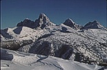
| The Idaho side of the Tetons: One of the many locations covered in Winter Tales and Trails |
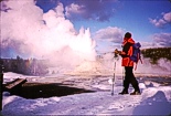
| Yellowstone in the winter: cross-country skiing, snowshoeing and backcountry skiing - it has all. |
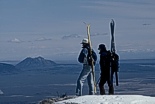
| Backcountry skiing & boarding: the incomparable Big Southern Butte. |