
 Using a Compass: Dealing With Declination
By Ron Watters, Professor Emeritus of Outdoor Education, Idaho State University
The following supplements a discussion on using a compass. To reach the first page of the series, click: Compass Techniques. (Or, if you'd rather pick from a list of topics, you'll find it here: Topic Index.)
Introduction
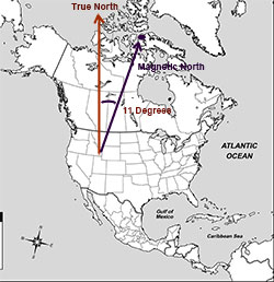
One of the most confounding aspects of using a compass is declination. Declination is the difference between true north and magnetic north. If you take bearing in the field and want to use it on a map (or visa versa), you must account for this difference. In the past - and many references still suggest this method - declination was accounted for by using an addition-subtraction method.
| . Need the current declination for your area? This will . help: Declination Calculation Tools |
Whether to add or subtract depends on whether you live in an area with an east or west declination. Various memory techniques have been employed, including the commonly used rhymes: "East is least" (add declination) and "West is best" (substract declination). But because there are a mix of variables: declination east, declination west, true north, magnetic north, and whether you are converting from compass to map or visa versa, knowing what to do - and when to do it - gets complicated.
In fact, the confusion that can result from trying to remember when to add or subtract can literally drive one bananas. I've seen well educated individuals in map classes who have become so completely frustrated using the addition-subtraction method that they've been driven nearly to tears. A young woman - who later became my wife - was one of those, and she was one very good reason why I changed my method of teaching.
When it comes to the outdoors, I believe strongly in the KISS principle: Keep It Simple Stupid. The simpler you keep procedures in the outdoors, the more apt you'll do things right.
Can I let you in on a secret? The secret is to work in one system: base all bearings on true north. There are two ways of accomplishing this:
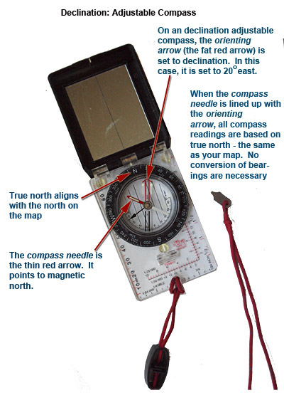
1. Use a Declination Adjustable Compass
By far the easiest way to solve this problem is to buy a compass in which declination can be set (see illustration, below). All you do is to turn the declination adjustment screw on the compass to the appropriate declination for your area and all readings are automatically converted to true north. There's no further bother. You can use it on the map. You can use it in the field. And you can work between the map and field and never have to think twice about declination. It will save you hours of frustration. If you're interested in purchasing a declination adjustable compass, here's my recommendation: Silva Ranger 15
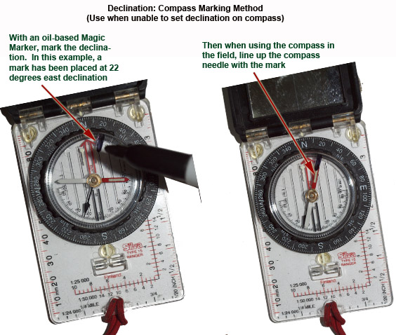
2. Mark Your Compass.
If you already have a plate compass - or the $55 - $60 declination adjustable compass, discussed above, is out of your price range - don't lose hope. There's another option.
You can place a mark your compass which effectively makes it into a declination adjustable unit. To do so, set the compass at 0 degrees. Take an oil-based Magic Marker and place a mark at the declination angle on top of the plastic capsule which houses the compass needle (see illustration, below).
For example, if your declination is 10 degrees west, place a mark at 350 degrees (360 degrees minus 10 degrees).
The usual procedure when you take bearings in the field is to line up the compass needle with the engraved arrow (also called orientating arrow), but in this method the compass needle is lined up with the mark. This has the effect of making all compass bearings based on true north. Compass bearings may applied directly to the map, and map bearings may be used directly in the field.
There is no subtracting or adding. Since the mark is in indelible ink, it can't be rubbed or washed off. It can, however, be removed with rubbing alcohol, or white gas (commonly carried on camping or backpacking trips) in the event that you go out of state to an area with a different declination.
To go to the first page in a series on how to use a compass, click: Compass Techniques. Or, if you'd rather pick from a list of topics, you'll find it here: Topic Index.